
- Dit onderwerp bevat 0 reacties, 1 deelnemer, en is laatst geüpdatet op 14 maart 2022 at 16:55 door Anna.
-
AuteurBerichten
-
-
14 maart 2022 om 16:55 #8154Anna@akrasko97
Doorbraak Quantum Gravity Sensor baant weg voor baanbrekende wereldkaart onder het aardoppervlak
Een onder de grond verborgen object is gelokaliseerd met behulp van kwantumtechnologie – een langverwachte mijlpaal met ingrijpende gevolgen voor de industrie, menselijke kennis en nationale veiligheid.
Onderzoekers van de University of Birmingham van de Britse National Quantum Technology Hub in Sensors and Timing hebben hun prestatie gerapporteerd in Nature. Het is de eerste ter wereld voor een kwantumzwaartekrachtgradiëntmeter buiten laboratoriumomstandigheden.
De kwantumzwaartekrachtgradiëntmeter, die werd ontwikkeld in opdracht van het Ministerie van Defensie en in het door de UKRI gefinancierde Gravity Pioneer-project, werd gebruikt om een tunnel te vinden die buiten in reële omstandigheden werd begraven, één meter onder het grondoppervlak. Het wint een internationale race om de technologie naar buiten te brengen.
De sensor detecteert variaties in microzwaartekracht met behulp van de principes van de kwantumfysica, die gebaseerd is op het manipuleren van de natuur op submoleculair niveau.
Het succes opent een commerciële weg naar een aanzienlijk verbeterde mapping van wat zich onder het maaiveld bevindt.
Dit zal betekenen:
· Lagere kosten en vertragingen bij bouw-, spoor- en wegenbouwprojecten.
· Verbeterde voorspelling van natuurlijke fenomenen zoals vulkaanuitbarstingen.
· Ontdekking van verborgen natuurlijke hulpbronnen en gebouwde structuren.
· Archeologische mysteries begrijpen zonder opgravingen te beschadigen.
Professor Kai Bongs, hoofd van Cold Atom Physics aan de Universiteit van Birmingham en hoofdonderzoeker van de Britse Quantum Technology Hub Sensors and Timing, zei: “Dit is een ‘Edison-moment’ in detectie dat de samenleving, het menselijk begrip en de economieën zal transformeren.
“Met deze doorbraak hebben we het potentieel om een einde te maken aan de afhankelijkheid van slechte records en geluk bij het onderzoeken, bouwen en repareren. Bovendien is een ondergrondse kaart van wat momenteel onzichtbaar is nu een belangrijke stap dichterbij, waarmee een einde komt aan een situatie waarin we meer weten over Antarctica dan wat zich een paar meter onder onze straten bevindt.”
Huidige zwaartekrachtsensoren worden beperkt door een reeks omgevingsfactoren. Een bijzondere uitdaging is trillingen, die de meettijd van alle zwaartekrachtsensoren voor landmeetkundige toepassingen beperken. Als deze beperkingen kunnen worden aangepakt, kunnen enquêtes sneller, uitgebreider en goedkoper worden.
De sensor die is ontwikkeld door Dr. Michael Holynski, hoofd van Atom Interferometry in Birmingham en hoofdauteur van de studie, en zijn team in Birmingham is een zwaartekrachtgradiëntmeter. Hun systeem overwint trillingen en een verscheidenheid aan andere milieu-uitdagingen om kwantumtechnologie met succes in het veld toe te passen.
De succesvolle detectie, gerealiseerd in samenwerking met civiel ingenieurs onder leiding van professor Nicole Metje van de School of Engineering, is het resultaat van een langetermijnontwikkelingsprogramma dat vanaf het begin nauw verbonden is met eindgebruikers.
Door deze doorbraak zullen toekomstige zwaartekrachtonderzoeken goedkoper, betrouwbaarder en 10 keer sneller worden geleverd, waardoor de tijd die nodig is voor onderzoeken wordt teruggebracht van een maand tot een paar dagen. Het heeft het potentieel om een reeks nieuwe toepassingen voor zwaartekrachtonderzoek te openen, wat een nieuwe lens in de ondergrond oplevert.
Professor George Tuckwell, directeur Geowetenschappen en Engineering bij RSK, zei: “Detectie van bodemomstandigheden zoals mijnbouw, tunnels en onstabiele grond is van fundamenteel belang voor ons vermogen om woningen, industrie en infrastructuur te ontwerpen, bouwen en onderhouden. De verbeterde capaciteit die deze nieuwe technologie vertegenwoordigt, kan de manier waarop we de grond in kaart brengen en deze projecten opleveren, veranderen”
Dr. Gareth Brown, gezamenlijke Project Technical Authority for Quantum Sensing en Senior Principal Scientist bij Dstl, zei: “Voor nationale defensie en veiligheid bieden nauwkeurige en snelle metingen van variaties in microzwaartekracht nieuwe mogelijkheden om het anders ondetecteerbare te detecteren en veiliger te navigeren in uitdagende omgevingen. Naarmate de zwaartekrachtsensortechnologie volwassen wordt, zullen toepassingen voor onderwaternavigatie en het onthullen van de ondergrond mogelijk worden.”
Hoe de kwantumzwaartekrachtsensor werkt
De kwantumzwaartekrachtsensor meet subtiele veranderingen in de trekkracht van zwaartekrachtvelden wanneer een wolk van atomen valt. Hoe groter het object en hoe groter het verschil in dichtheid van het object met zijn omgeving, hoe sterker het meetbare verschil in trekkracht. Maar trillingen, kanteling van instrumenten en verstoring door magnetische en thermische velden hebben het omzetten van de kwantumtheorie in commerciële realiteit een uitdaging gemaakt. De doorbraak van de kwantumsensor in Birmingham is de eerste die deze echte uitdagingen aangaat en een onderzoek met hoge ruimtelijke resolutie uitvoert. Het verwijderen van ruis als gevolg van trillingen zal het in kaart brengen van de zwaartekracht met een hoge ruimtelijke resolutie ontgrendelen.
=================== =======================
Quantum Gravity Sensor Breakthrough Paves Way for Groundbreaking Map of World Under Earth’s Surface

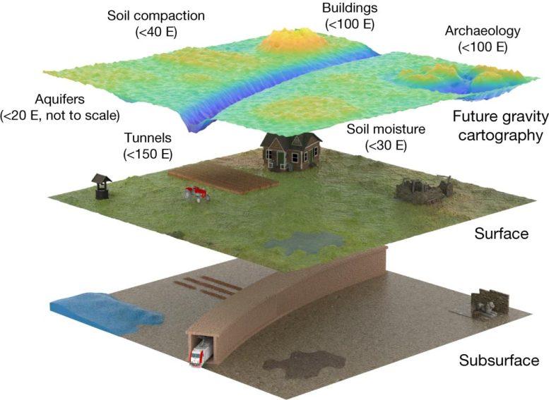
A perspective of future gravity cartography being used with 0.5 m spatial resolution over a region, at an uncertainty level of 20 E. Expected signal sizes for a range of applications are shown. Credit: Stray et al. 2022 Nature DOI: 10.1038/s41586-021-04315-3
An object hidden below ground has been located using quantum technology — a long-awaited milestone with profound implications for industry, human knowledge, and national security.
University of Birmingham researchers from the UK National Quantum Technology Hub in Sensors and Timing have reported their achievement in Nature. It is the first in the world for a quantum gravity gradiometer outside of laboratory conditions.
The quantum gravity gradiometer, which was developed under a contract for the Ministry of Defence and in the UKRI-funded Gravity Pioneer project, was used to find a tunnel buried outdoors in real-world conditions one meter below the ground surface. It wins an international race to take the technology outside.
The sensor works by detecting variations in microgravity using the principles of quantum physics, which is based on manipulating nature at the sub-molecular level.
The success opens a commercial path to significantly improved mapping of what exists below ground level.
This will mean:
- Reduced costs and delays to construction, rail, and road projects.
Improved prediction of natural phenomena such as volcanic eruptions.
Discovery of hidden natural resources and built structures.
Understanding archaeological mysteries without damaging excavation.
Professor Kai Bongs, Head of Cold Atom Physics at the University of Birmingham and Principal Investigator of the UK Quantum Technology Hub Sensors and Timing, said: “This is an ‘Edison moment’ in sensing that will transform society, human understanding, and economies.
“With this breakthrough we have the potential to end reliance on poor records and luck as we explore, build and repair. In addition, an underground map of what is currently invisible is now a significant step closer, ending a situation where we know more about Antarctica than what lies a few feet below our streets.”
Current gravity sensors are limited by a range of environmental factors. A particular challenge is vibration, which limits the measurement time of all gravity sensors for survey applications. If these limitations can be addressed, surveys can become faster, more comprehensive, and lower cost.
The sensor developed by Dr. Michael Holynski, Head of Atom Interferometry at Birmingham and lead author of the study, and his team at Birmingham is a gravity gradiometer. Their system overcomes vibration and a variety of other environmental challenges in order to successfully apply quantum technology in the field.
The successful detection, realized in collaboration with civil engineers led by Professor Nicole Metje of the School of Engineering, is the culmination of a long-term development program that has been closely linked to end-users from its outset.
This breakthrough will allow future gravity surveys to be cheaper, more reliable, and delivered 10 times faster, reducing the time needed for surveys from a month to a few days. It has the potential to open a range of new applications for gravity survey, providing a new lens into the underground.
Professor George Tuckwell, Director for Geoscience and Engineering at RSK, said: “Detection of ground conditions such as mine workings, tunnels, and unstable ground is fundamental to our ability to design, construct and maintain housing, industry, and infrastructure. The improved capability that this new technology represents could transform how we map the ground and deliver these projects”
Dr. Gareth Brown, joint Project Technical Authority for Quantum Sensing and Senior Principal Scientist at Dstl, said: “For national Defence and Security, accurate and rapid measurements of variations in microgravity open up new opportunities to detect the otherwise undetectable and navigate more safely in challenging environments. As gravity sensing technology matures, applications for underwater navigation and revealing the subterranean will become possible.”
How the quantum gravity sensor works
The quantum gravity sensor measures subtle changes in the pulling strength of gravitational fields when a cloud of atoms is dropped. The bigger the object and the greater the difference in density of the object from its surroundings, the stronger the measurable difference in pull. But vibration, instrument tilt and disruption from magnetic and thermal fields have made turning quantum theory into commercial reality challenging. The Birmingham quantum sensor breakthrough is the first to meet these real-world challenges and perform a high spatial resolution survey. The removal of noise due to vibration will unlock gravity mapping at high spatial resolution.
Reference: “Quantum sensing for gravity cartography” by Ben Stray, Andrew Lamb, Aisha Kaushik, Jamie Vovrosh, Anthony Rodgers, Jonathan Winch, Farzad Hayati, Daniel Boddice, Artur Stabrawa, Alexander Niggebaum, Mehdi Langlois, Yu-Hung Lien, Samuel Lellouch, Sanaz Roshanmanesh, Kevin Ridley, Geoffrey de Villiers, Gareth Brown, Trevor Cross, George Tuckwell, Asaad Faramarzi, Nicole Metje, Kai Bongs and Michael Holynski, 23 February 2022, Nature.
DOI: 10.1038/s41586-021-04315-3The breakthrough is a collaboration between the University of Birmingham, environmental, engineering and sustainability solutions provider RSK, Dstl (the Defence Science and Technology Laboratory, part of the UK Ministry of Defence), and technology company Teledyne e2v. The project is funded by UK Research and Innovation (UKRI) as part of the UK National Quantum Technologies Program and under contract from the Ministry of Defence.
- Reduced costs and delays to construction, rail, and road projects.
-
-
AuteurBerichten
- Je moet ingelogd zijn om een antwoord op dit onderwerp te kunnen geven.